Everest Region A Hotspot Of Cryosphere-Linked Hazards
ICIMOD Press Release
The Everest region is a hotspot of cryosphere-linked hazards. ICIMOD’s new study on Nepal’s 2024 Thame flood confirms
Kathmandu, 14 October 2025 – A new study on a 2024 glacial lake outburst flood in the Everest region, published today, finds that a ‘devastating and complex, chain reaction’ of geological and geomorphological factors amplified the destructive power of the flood that decimated the iconic high-altitude trekking village of Thame, in Solokhumbu, Nepal, on 16 August 2024.
Thame Valley Glacial Lake Outburst Flood – Causes, Impacts, and Future Risks, authored by risk experts at the International Centre for Integrated Mountain Development (ICIMOD) Sudan Bikash Maharjan, Tenzing Chogyal Sherpa, and Arun Bhakta Shrestha, confirms that a rock avalanche triggered a powerful displacement wave when it hit a glacial lake at 4,900 metres, causing the lake to breach and releasing 156,000 cubic metres of water. This outflow fell 120 metres, amplifying its erosive power – and hit a second lake, whose moraine-dam then breached, leaving a hole 22 metres high (the height of an eight-storey building) and 51 metres wide and releasing an additional 303,000 cubic metres of water. The combined waters transformed into a ‘hyper-concentrated flow of slurry’ as they swept downstream, transporting debris, including large boulders, 80km downstream and eroding riverbanks in its path.
A natural narrowing of the river channel (downstream of the Thyanbo outwash plain) combined with the draining of a temporary ponding of floodwaters tragically amplified the flood’s erosive force. This went on to cause erosion and landslides, and mobilised large quantities of debris as it moved towards and ultimately covered the entire half-a-kilometre wide valley floor near the Thame Village. The flood caused extensive destruction, including homes, a school, a health post, a bridge, and damaged a hydropower plant, but thanks to the event’s occurrence in daylight and the phased nature of the flood due to the ponding, no loss of life. Nepal has seen over 90 GLOFs since the early 1920s, and the Everest region has withstood five significant events in less than 50 years – including the 1985 GLOF of Dig Tsho, which struck the neighbouring valley to the Thame event, wiping away a newly constructed hydropower plant.
GLOFs are among the most destructive and prominent hazards in high-mountain regions. Capable of releasing millions of cubic meters of water and debris within hours, they can cause catastrophic damage downstream: unleashing torrents of water that obliterate communities, devastate infrastructure, and permanently reshape landscapes. The accelerating impacts of climate change, particularly in the Hindu Kush Himalaya (HKH) region, are compounding these risks. The HKH, warming at an average of 0.28 degrees Celsius per decade, is experiencing unprecedented glacier mass loss, which has increased by 65% in recent decades compared to earlier periods. This rapid glacier retreat has fuelled the proliferation of over 25,000 glacial lakes across the region, spanning the Amu Darya, Indus, Ganges, Brahmaputra, and Irrawaddy basins. Sudan Bikash Maharjan, Remote Sensing Analyst at ICIMOD and one of the authors of the study, said: “The Hindu Kush Himalayas has more than 25,000 glacial lakes, and Thame shows us that we need to spend much more effort in understanding and preventing the risks posed by even the relatively smaller lakes. In this case, the additional geological and morphological characteristics of a landscape intensified the impact of this climate-driven event to cause catastrophic damage, though mercifully, with no loss of life.”
Study co-author Tenzing Chogyal Sherpa, ICIMOD Cryosphere Analyst, says: “As climate extremes intensify, the Thame flood is both a stark reminder and a moment of reflection, showing how mountain communities are already bearing the brunt of climate-induced disasters. In line with this year’s International Day for Disaster Risk Reduction theme on funding resilience, it reinforces the urgent need to invest in preparedness, strengthen scientific understanding, and support the people most at risk. Events like these also serve as crucial moments for understanding and communicating the realities of climate change, reminding us that the mountains are speaking, we just need to listen.” The study outlines several urgent specific actions in Thame itself – such as protecting tension cracks from direct flow or rapid infiltration of flood water, rain or snowmelt, supporting riverbanks from subsidence – as well as the development of a long-term flood risk management plan for the valley. It also advises on the growing urgency to bolster monitoring of high-altitude glaciated regions across the HKH.
The study, launched at an event to mark International Disaster Risk Reduction Day co-hosted by Nepal’s National Disaster Risk Reduction Management Authority (NDRRMA), Government of Nepal, Disaster Preparedness Network-Nepal (DPNet-Nepal), ICIMOD yesterday, was conducted jointly by ICIMOD and Nepal’s NDRRMA, along with partners from the Asian Development Bank and BGC Engineering, and combined satellite analysis, drone surveys, and on-ground geomorphological assessments. Support for the study also came from the District Administration of Solokhumbu, as well as the Sagarmatha Pollution Control Committee, which provided drone footage to help in the technical assessments. Arun Bhakta Shrestha, Senior Advisor at ICIMOD and study co-author, states, “The Thame case shows that glacial hazards are intensifying as the Hindu Kush Himalaya warms nearly three times faster than the global average. In the last two years alone, we have seen several high-altitude hazards, including GLOFs, across the region. This points to two immediate needs: more hydrological and meteorological monitoring stations generating real-time information, and engineering measures, including bank protection measures to reduce damages from future events.” The Thame disaster is the latest in a series of events to reinforce the need to translate cryospheric and disaster-related science into actionable policy.
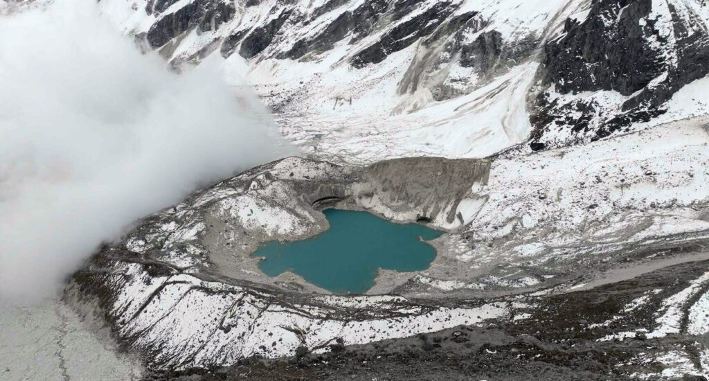
Photo Description: Drone image captured on 17 October 2024 shows Rhindi Cho, with an ice cliff indicating that the lake was formed on the glacier surface, and an erosional scar on the end moraine caused by the flood impact. PHOTO: FOOTAGE FROM SPCC